ファイル:USA Mississippi Tupelo area NPS map.jpg
高解像度版はありません。
USA_Mississippi_Tupelo_area_NPS_map.jpg (285 × 305 ピクセル、ファイルサイズ: 28キロバイト、MIME タイプ: image/jpeg)
ウィキメディア・コモンズのファイルページにある説明を、以下に表示します。
|
概要
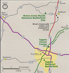
| 解説 | Area map of Tupelo, Mississippi, showing city limits, roads, and national parks or historic landmarks. Map by US NPS. |
| 日付 | |
| 原典 | US National Park Service webpage: http://pagebang.com/cgi/nph-proxy.cgi/111011A/http/www.nps.gov/brcr/planyourvisit/index.htm |
| 作者 | US Federal Government: Department of the Interior |
| その他のバージョン | (none) |
ライセンス
| This image or media file contains material based on a work of a National Park Service employee, created as part of that person's official duties. As a work of the U.S. federal government, such work is in the public domain in the United States. See the NPS website and NPS copyright policy for more information. |
ファイルの履歴
過去の版のファイルを表示するには、その版の日時をクリックしてください。
| 日付と時刻 | サムネイル | 寸法 | 利用者 | コメント | |
|---|---|---|---|---|---|
| 現在の版 | 2007年7月19日 (木) 21:41 | | 285 × 305 (28キロバイト) | Wikid77 | {{Information |Description=Area map of Tupelo, Mississippi, showing city limits, roads, and national parks or historic landmarks. Map by US NPS. |Source=US en:National Park Service webpage: http:// |
ファイルの使用状況
以下の 2 ページがこのファイルを使用しています:
グローバルなファイル使用状況
以下に挙げる他のウィキがこの画像を使っています:
- en.wikipedia.org での使用状況
- eo.wikipedia.org での使用状況
- he.wikipedia.org での使用状況
- ka.wikipedia.org での使用状況
- nl.wikipedia.org での使用状況
- pt.wikipedia.org での使用状況
- sv.wikipedia.org での使用状況