ファイル:WarRelocationMap.jpg

高解像度版はありません。
WarRelocationMap.jpg (628 × 408 ピクセル、ファイルサイズ: 128キロバイト、MIME タイプ: image/jpeg)
ウィキメディア・コモンズのファイルページにある説明を、以下に表示します。
|
概要
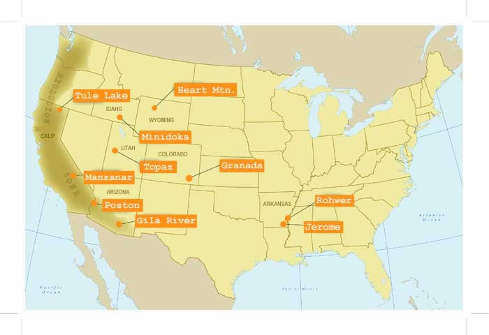
| 解説 | アメリカ合衆国日系人収容所所在地地図 |
| 原典 |
http://www.nps.gov/manz/historyculture/images/WarRelocationMap.jpg |
| 作者 | The National Park Service (NPS), U.S. Department of the Interior |
ライセンス
| This image or media file contains material based on a work of a National Park Service employee, created as part of that person's official duties. As a work of the U.S. federal government, such work is in the public domain in the United States. See the NPS website and NPS copyright policy for more information. |
ファイルの履歴
過去の版のファイルを表示するには、その版の日時をクリックしてください。
| 日付と時刻 | サムネイル | 寸法 | 利用者 | コメント | |
|---|---|---|---|---|---|
| 現在の版 | 2020年10月16日 (金) 16:20 | | 628 × 408 (128キロバイト) | WFinch | no crops |
| 2006年9月25日 (月) 15:08 |  | 700 × 480 (27キロバイト) | Californiacondor~commonswiki | アメリカ合衆国日系人収容所所在地地図 |
ファイルの使用状況
以下のページがこのファイルを使用しています:
グローバルなファイル使用状況
以下に挙げる他のウィキがこの画像を使っています:
- ca.wikipedia.org での使用状況
- en.wikipedia.org での使用状況
- fr.wikipedia.org での使用状況
- www.wikidata.org での使用状況