ファイル:Wfm james ross straight.png

このプレビューのサイズ: 800 × 593 ピクセル。 その他の解像度: 320 × 237 ピクセル | 640 × 474 ピクセル | 1,024 × 758 ピクセル | 1,280 × 948 ピクセル。
元のファイル (1,280 × 948 ピクセル、ファイルサイズ: 2.7メガバイト、MIME タイプ: image/png)
ウィキメディア・コモンズのファイルページにある説明を、以下に表示します。
|
概要
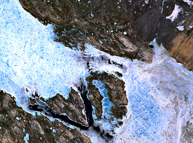
The James Ross Straight northeast of King William Island. Sea ice fills the straight, forming a bridge to Tennent Island (in the west) and Matty Island (further to the east).
NASA Landsat 7 satellite image, collected using NASA World Wind.
ライセンス
| この画像は、Blue Marble、MODIS、Landsat、SRTM、USGS、GLOBEなどのパブリックドメイン・レイヤーを使用したNASAの地球儀ソフトウェア「World Wind」のスクリーンショットであるため、パブリックドメインの状態にあります。
|
 |
ファイルの履歴
過去の版のファイルを表示するには、その版の日時をクリックしてください。
| 日付と時刻 | サムネイル | 寸法 | 利用者 | コメント | |
|---|---|---|---|---|---|
| 現在の版 | 2005年9月2日 (金) 18:38 | | 1,280 × 948 (2.7メガバイト) | Finlay McWalter | The James Ross Straight northeast of en:King William Island. Sea ice fills the straight, forming a bridge to Tennent Island (in the west) and Matty Island (further to the east). NASA Landsat 7 satellite image, collected using NASA World Wind. |
ファイルの使用状況
以下のページがこのファイルを使用しています:
グローバルなファイル使用状況
以下に挙げる他のウィキがこの画像を使っています:
- bg.wikipedia.org での使用状況
- de.wikipedia.org での使用状況
- en.wikipedia.org での使用状況
- es.wikipedia.org での使用状況
- fi.wikipedia.org での使用状況
- fr.wikipedia.org での使用状況
- it.wikipedia.org での使用状況
- ml.wikipedia.org での使用状況
- nl.wikipedia.org での使用状況
- pt.wikipedia.org での使用状況
- ru.wikipedia.org での使用状況
- zh.wikipedia.org での使用状況