ファイル:1853 Kaei 6 Japanese Map of the World - Geographicus - ChikyuBankokuHozu-nakajima-1853.jpg

このプレビューのサイズ: 800 × 466 ピクセル。 その他の解像度: 320 × 186 ピクセル | 640 × 372 ピクセル | 1,024 × 596 ピクセル | 1,280 × 745 ピクセル | 2,560 × 1,490 ピクセル | 6,000 × 3,492 ピクセル。
元のファイル (6,000 × 3,492 ピクセル、ファイルサイズ: 5.51メガバイト、MIME タイプ: image/jpeg)
ウィキメディア・コモンズのファイルページにある説明を、以下に表示します。
|
概要
| Shintei - Chikyu Bankoku Hozu (Square Map of all the Countries on the Globe) | |||
|---|---|---|---|
| 作者 | |||
| タイトル |
Shintei - Chikyu Bankoku Hozu (Square Map of all the Countries on the Globe) |
||
| 解説 |
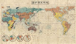
English: A very interesting 1853 (Kaei 6) Japanese world map by Suido Nakajima. Presented on a cylindrical projection, this map marks a significant advancement in Japanese globular cartography and a far more sophisticated adaptation of western cartographic standards than is evidenced in most earlier Japanese world maps. No longer reliant on 17th century Dutch maps acquired via the Dutch East India Company’s (VOC) trade concession in Nagasaki, the Japanese have here abandoned many of the antiquated cartographic notions, such as an insular California, which were common in Japanese maps of the previous decade. Japanese cartographers may have been motivated to update their traditional world view in the light of the explosion of cartographic ideas associated with the arrival in Edo Harbor of the American Commodore Matthew Perry in the same year this map was published. As a whole this map offers a sophisticated cartographic presentation of the world embracing the most up to date cartographic knowledge available in the mid-19th century. Though adapted to the Japanese printing style, this map presents a generally accurate world view. British Claims to Washington and British Columbia are noted in North America, Australia and the Pacific are accurately rendered, as are the discoveries of Vitus Bering and James Cook in the Arctic, and Africa is clearly pre-Speke. The disputed East Sea / Sea of Japan / Sea of Korea is here labeled as the Sea of Joseon (Korea), which some scholars suggests indicates Japanese acceptance of the “Sea of Korea” convention. Four hemispheres appear in the lower left quadrant, from left, the southern, northern, eastern, and western. All are on a stereographic projection. The map is printed on woodblock and hand colored in vivid, blues, greens, oranges, and yellows. A fine example of the redefined Japanese cartography style of the later Tokugawa period. |
||
| 日付 | 1853年 (dated Kaei 6) | ||
| 寸法 | 高さ: 31 in (78.7 cm);幅: 51 in (129.5 cm) | ||
| 台帳番号 |
Geographicus link: ChikyuBankokuHozu-nakajima-1853 |
||
| 情報源/撮影者 |
|
||
ライセンス
|
このファイルは、パブリックドメインの状態にある平面的な美術の著作物を写真術によって忠実に複製したものです。このような複製はアメリカ合衆国においてパブリックドメインの状態にあります。その他の地域では再利用に制限がかかる場合があります。詳しくはReuse of PD-Art photographsをご覧ください。美術の著作物としての原図は、次の理由によりパブリックドメインの状態にあります。
| ||||
ファイルの履歴
過去の版のファイルを表示するには、その版の日時をクリックしてください。
| 日付と時刻 | サムネイル | 寸法 | 利用者 | コメント | |
|---|---|---|---|---|---|
| 現在の版 | 2011年3月25日 (金) 05:07 | | 6,000 × 3,492 (5.51メガバイト) | BotMultichillT | {{subst:User:Multichill/Geographicus |link=http://www.geographicus.com/P/AntiqueMap/ChikyuBankokuHozu-nakajima-1853 |product_name=1853 Kaei 6 Japanese Map of the World |map_title=Shintei - Chikyu Bankoku Hozu (Square Map of all the Countries on the Globe) |
ファイルの使用状況
グローバルなファイル使用状況
以下に挙げる他のウィキがこの画像を使っています:
- fr.wikipedia.org での使用状況
- zh.wikipedia.org での使用状況