ファイル:Long Beach Street Circuit IndyCar.svg

この SVG ファイルのこの PNG プレビューのサイズ: 800 × 568 ピクセル. その他の解像度: 320 × 227 ピクセル | 640 × 454 ピクセル | 1,024 × 726 ピクセル | 1,280 × 908 ピクセル | 2,560 × 1,816 ピクセル | 1,397 × 991 ピクセル。
元のファイル (SVG ファイル、1,397 × 991 ピクセル、ファイルサイズ: 89キロバイト)
ウィキメディア・コモンズのファイルページにある説明を、以下に表示します。
|
概要
| 解説 |
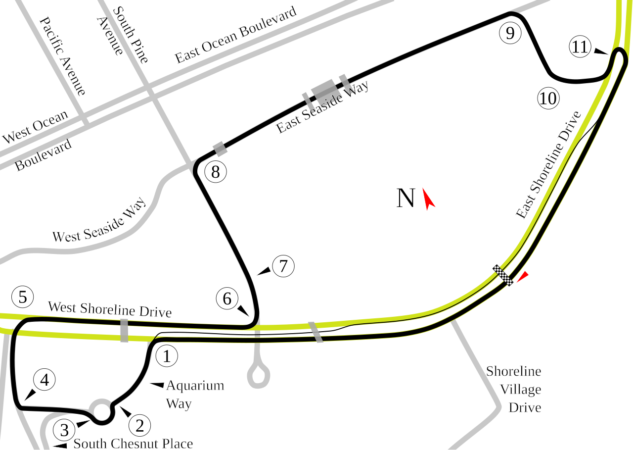
English: Track map of the Long Beach Street Racing Circuit. The yellow and gray lines are the local streets for reference. The gray transparent blocks over the streets and course are overpasses that interfere with the transmissions from the race cars. |
| 原典 | 投稿者自身による著作物 |
| 作者 | Will Pittenger |
| カメラの位置 | | 以下のサービスでこの位置を確認する: オープンストリートマップ |
|---|
ライセンス
| この著作物の著作権者である私は、この著作物における権利を放棄しパブリックドメインとします。これは全世界で適用されます。 一部の国では、これが法的に可能ではない場合があります。その場合は、次のように宣言します。 私は、あらゆる人に対して、法により必要とされている条件を除き、如何なる条件も課すことなく、あらゆる目的のためにこの著作物を使用する権利を与えます。 |
ファイルの履歴
過去の版のファイルを表示するには、その版の日時をクリックしてください。
| 日付と時刻 | サムネイル | 寸法 | 利用者 | コメント | |
|---|---|---|---|---|---|
| 現在の版 | 2008年7月19日 (土) 07:59 | | 1,397 × 991 (89キロバイト) | Will Pittenger | New version gets around Mediawiki/RSVG's problem with Text on paths (the text is hidden) by converting that text into paths. If you need to edit the file, please use the old version. |
| 2008年7月19日 (土) 07:07 |  | 1,397 × 991 (67キロバイト) | Will Pittenger | {{Information |Description={{en|1=Track map of the Long Beach Street Racing Circuit. The yellow and gray lines are the local streets for reference. The gray transparent blocks over the streets and course are overpasses that i |
ファイルの使用状況
以下のページがこのファイルを使用しています:
グローバルなファイル使用状況
以下に挙げる他のウィキがこの画像を使っています:
- ast.wikipedia.org での使用状況
- bg.wikipedia.org での使用状況
- de.wikipedia.org での使用状況
- Long Beach Grand Prix Circuit
- Liste der IndyCar/ChampCar-Rennstrecken
- Toyota Grand Prix of Long Beach 2012
- Toyota Grand Prix of Long Beach 2013
- Toyota Grand Prix of Long Beach 2014
- Toyota Grand Prix of Long Beach 2015
- Grand Prix of Long Beach 2022
- Kategorie:Long Beach Grand Prix Circuit
- Grand Prix of Long Beach 2023
- Grand Prix of Long Beach 2021
- Grand Prix of Long Beach 2024
- en.wikipedia.org での使用状況
- Grand Prix of Long Beach
- Toyota Pro/Celebrity Race
- 2006 Toyota Grand Prix of Long Beach
- List of Champ Car circuits
- 2007 Toyota Grand Prix of Long Beach
- 2005 Toyota Grand Prix of Long Beach
- User talk:Chubbennaitor/archive2
- 2004 Toyota Grand Prix of Long Beach
- User talk:Barkjon/Archive 2
- 2008 American Le Mans Series at Long Beach
- 2003 Toyota Grand Prix of Long Beach
- Wikipedia:WikiProject Formula One/Newsletter/200808
- User talk:Hellboy2hell/archive2
- User talk:NapHit/Archive 1
- User talk:4u1e/archive5
- 2008 Toyota Grand Prix of Long Beach
- User talk:Typ932/Archive 3
- User talk:Midgrid/Archive 6
- User talk:Thelb4/Archive 5
- User talk:Chubbennaitor/Archive7
- User talk:Readro/Archive 3
- User talk:Donnie Park/Archive 1
- 2009 American Le Mans Series at Long Beach
- 2009 Toyota Grand Prix of Long Beach
- User talk:The359/Archive 4
- 2002 Toyota Grand Prix of Long Beach
- List of American Le Mans Series circuits
- User talk:Cs-wolves/Archive 3
- User talk:Bam123456789/Archive 1
- 2010 American Le Mans Series at Long Beach
- 2010 Toyota Grand Prix of Long Beach
- List of IndyCar Series racetracks
- 2011 American Le Mans Series at Long Beach
- 2011 Toyota Grand Prix of Long Beach
- 2012 American Le Mans Series at Long Beach
- 2012 Toyota Grand Prix of Long Beach
- 2007 Toyota Grand Prix of Long Beach (American Le Mans Series race)
このファイルのグローバル使用状況を表示する。