ファイル:NYCS map 7.svg

この SVG ファイルのこの PNG プレビューのサイズ: 490 × 599 ピクセル. その他の解像度: 196 × 240 ピクセル | 393 × 480 ピクセル | 628 × 768 ピクセル | 838 × 1,024 ピクセル | 1,676 × 2,048 ピクセル | 648 × 792 ピクセル。
元のファイル (SVG ファイル、648 × 792 ピクセル、ファイルサイズ: 379キロバイト)
ウィキメディア・コモンズのファイルページにある説明を、以下に表示します。
|
概要
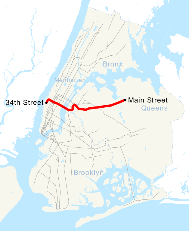
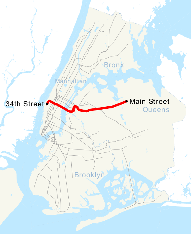
| 解説 | This is a map showing the New York City Subway's 7 service. It was created with TIGER/Line GIS data (water and boundaries) and my own data (subway lines and stations, traced on TIGER/Line road data). If you would like a copy of the subway data, email me. |
| 日付 | 2007年5月1日 (当初のアップロード日) |
| 原典 | コンピュータが読み取れる情報は提供されていませんが、投稿者自身による著作物だと推定されます(著作権の主張に基づく) |
| 作者 | コンピュータが読み取れる情報は提供されていませんが、NE2だと推定されます(著作権の主張に基づく) |
ライセンス
| この著作物の著作権者である私は、この著作物における権利を放棄しパブリックドメインとします。これは全世界で適用されます。 一部の国では、これが法的に可能ではない場合があります。その場合は、次のように宣言します。 私は、あらゆる人に対して、法により必要とされている条件を除き、如何なる条件も課すことなく、あらゆる目的のためにこの著作物を使用する権利を与えます。 |
ファイルの履歴
過去の版のファイルを表示するには、その版の日時をクリックしてください。
| 日付と時刻 | サムネイル | 寸法 | 利用者 | コメント | |
|---|---|---|---|---|---|
| 現在の版 | 2015年9月12日 (土) 06:49 | | 648 × 792 (379キロバイト) | Jc86035 | moved text marker for 34th St |
| 2015年9月12日 (土) 06:38 |  | 648 × 792 (377キロバイト) | Jc86035 | fixed text (sans-serif to Arial) to match and changed it to path, fixed/simplified path of 7 extension, cleaned up with SVGCleaner | |
| 2015年9月11日 (金) 19:27 |  | 648 × 792 (380キロバイト) | DMacks | remove "Times Square" label (previously-removed box had covered it) | |
| 2015年9月11日 (金) 15:29 |  | 648 × 792 (390キロバイト) | DMacks | remove white rectangle just above "Times Square" | |
| 2015年9月2日 (水) 15:45 |  | 648 × 792 (390キロバイト) | FlushingLocal | Reverted to version as of 15:43, 2 September 2015 | |
| 2015年9月2日 (水) 15:45 |  | 648 × 792 (390キロバイト) | FlushingLocal | Updated again to an issue with the original file. | |
| 2015年9月2日 (水) 15:43 |  | 648 × 792 (390キロバイト) | FlushingLocal | Updated 7 Train Map to 34 St - Hudson Yards as the new terminal and removed Times Square | |
| 2011年10月29日 (土) 10:48 |  | 648 × 792 (464キロバイト) | Robot8A | text to path because you can't see it properly in article | |
| 2007年5月1日 (火) 00:04 |  | 648 × 792 (389キロバイト) | NE2 | == Summary == This is a map showing the New York City Subway's 7 service. It was created with TIGER/Line GIS data (water and boundaries) and my own data (subway lines and stations, traced on TIGER/Line road data). If you would like a copy of the subway da |
ファイルの使用状況
以下のページがこのファイルを使用しています:
グローバルなファイル使用状況
以下に挙げる他のウィキがこの画像を使っています:
- ca.wikipedia.org での使用状況
- de.wikipedia.org での使用状況
- en.wikipedia.org での使用状況
- es.wikipedia.org での使用状況
- et.wikipedia.org での使用状況
- fi.wikipedia.org での使用状況
- fr.wikipedia.org での使用状況
- he.wikipedia.org での使用状況
- ko.wikipedia.org での使用状況
- lmo.wikipedia.org での使用状況
- nl.wikipedia.org での使用状況
- no.wikipedia.org での使用状況
- pl.wikipedia.org での使用状況
- pt.wikipedia.org での使用状況
- ru.wikipedia.org での使用状況
- www.wikidata.org での使用状況
- zh.wikipedia.org での使用状況