ファイル:PIA09211.jpg
元のファイル (1,544 × 1,292 ピクセル、ファイルサイズ: 330キロバイト、MIME タイプ: image/jpeg)
ウィキメディア・コモンズのファイルページにある説明を、以下に表示します。
|
概要
| 解説 |
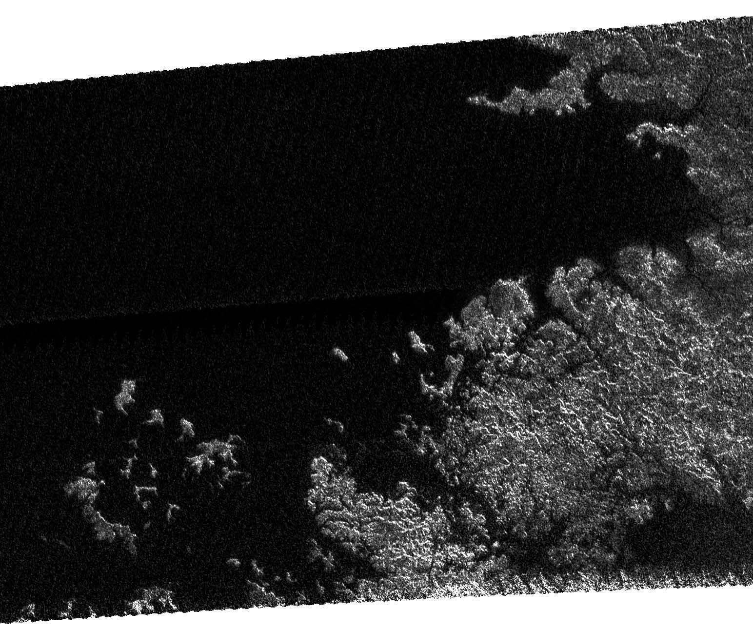
On May 12, 2007, Cassini completed its 31st flyby of Saturn's moon Titan, which the team calls T30. The radar instrument obtained this image showing the coastline and numerous island groups of a portion of a large sea, consistent with the larger sea seen by the Cassini imaging instrument (See Seeing Farther North). Like other bodies of liquid seen on Titan, this feature reveals channels, islands, bays, and other features typical of terrestrial coastlines, and the liquid, most likely a combination of methane and ethane, appears very dark to the radar instrument. What is striking about this portion of the sea compared to other liquid bodies on Titan is the relative absence of brighter regions within it, suggesting that the depth of the liquid here exceeds tens of meters (tens of yards). Of particular note is the presence of isolated islands, which follow the same direction as the peninsula to their lower right, suggesting that they may be part of a mountain ridgeline that has been flooded. This is analogous to, for example, Catalina Island off the coast of Southern California. The image as shown is about 160 kilometers (100 miles) by 270 kilometers (170 miles) at 300-meter (980-foot) resolution. The image is centered near 70 degrees north latitude and 310 west longitude. |
| 日付 | |
| 原典 | http://saturn.jpl.nasa.gov/multimedia/images/image-details.cfm?imageID=2614 |
| 作者 | NASA/JPL |
ライセンス
| このファイルはアメリカ航空宇宙局(NASA)によって作成されたものです。NASAの著作権の方針では、特記事項が無い場合、NASAの資料はパブリックドメインとなります。 (詳しくはTemplate:PD-USGov、NASAの著作権の方針について(英語)又はジェット推進研究所(JPL)の画像使用に関するガイドライン(英語)をご覧ください。) |
||
 |
注意事項:
|
ファイルの履歴
過去の版のファイルを表示するには、その版の日時をクリックしてください。
| 日付と時刻 | サムネイル | 寸法 | 利用者 | コメント | |
|---|---|---|---|---|---|
| 現在の版 | 2007年5月24日 (木) 17:12 | | 1,544 × 1,292 (330キロバイト) | PeterfromTitan~commonswiki | {{Information |Description=On May 12, 2007, Cassini completed its 31st flyby of Saturn's moon Titan, which the team calls T30. The radar instrument obtained this image showing the coastline and numerous island groups of a portion of a large sea, consisten |
ファイルの使用状況
以下のページがこのファイルを使用しています:
グローバルなファイル使用状況
以下に挙げる他のウィキがこの画像を使っています:
- ar.wikipedia.org での使用状況
- ca.wikipedia.org での使用状況
- en.wikipedia.org での使用状況
- hi.wikipedia.org での使用状況
- hy.wikipedia.org での使用状況
- ka.wikipedia.org での使用状況
- nl.wikipedia.org での使用状況
- pt.wikipedia.org での使用状況
- ru.wikipedia.org での使用状況
- ta.wikipedia.org での使用状況
- xmf.wikipedia.org での使用状況
- zh.wikipedia.org での使用状況