ファイル:Plan tramway reims.png
このプレビューのサイズ: 271 × 600 ピクセル。 その他の解像度: 108 × 240 ピクセル | 217 × 480 ピクセル | 1,000 × 2,213 ピクセル。
元のファイル (1,000 × 2,213 ピクセル、ファイルサイズ: 2.33メガバイト、MIME タイプ: image/png)
ウィキメディア・コモンズのファイルページにある説明を、以下に表示します。
|
概要
| 解説 |
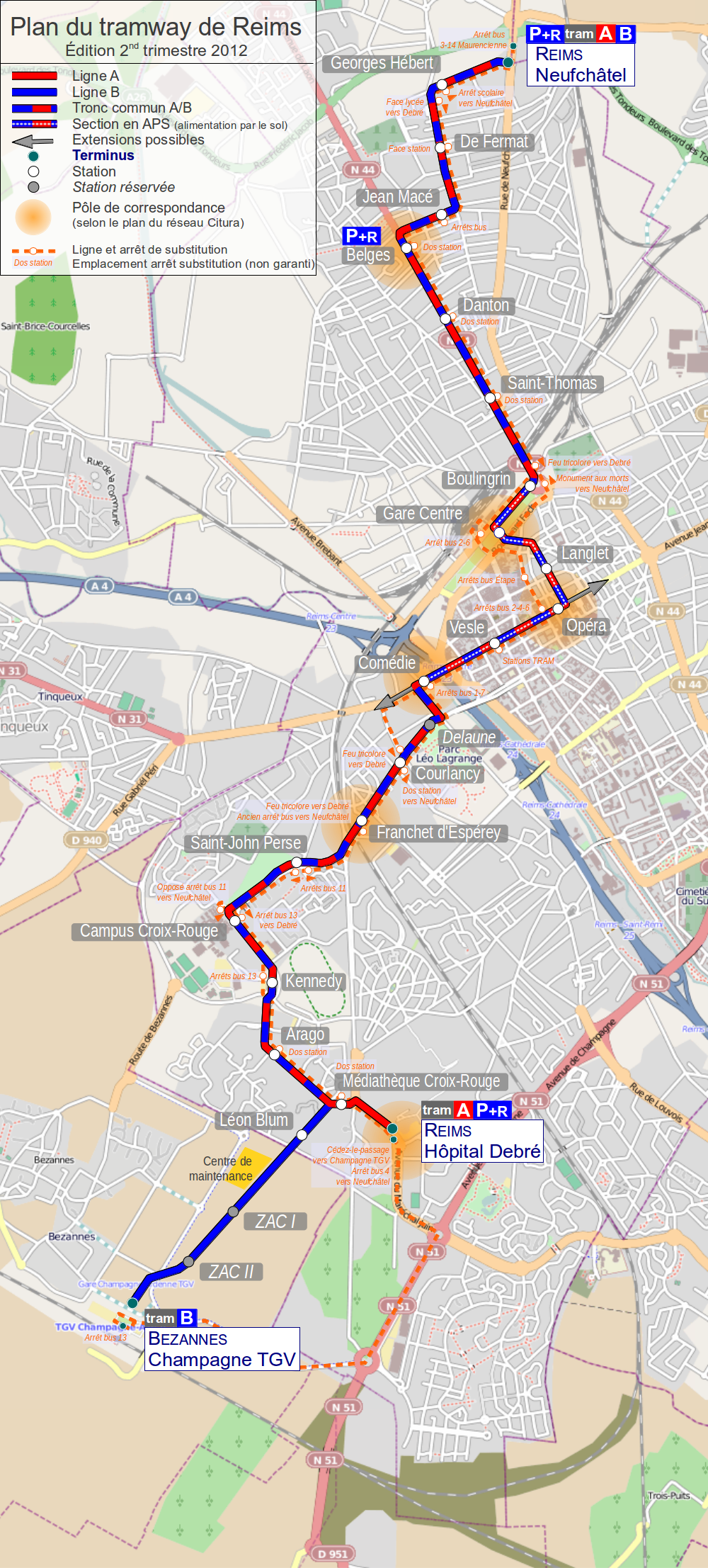
English: Map of tramway in Rheims France
Français : Plan du tramway de Reims, France |
| 日付 | |
| 原典 | 投稿者自身による著作物. Background map: © OpenStreetMap and contributors, CC BY-SA. |
| 作者 | Daiima |
ライセンス
このファイルはクリエイティブ・コモンズ 表示-継承 2.0 一般ライセンスのもとに利用を許諾されています。
- あなたは以下の条件に従う場合に限り、自由に
- 共有 – 本作品を複製、頒布、展示、実演できます。
- 再構成 – 二次的著作物を作成できます。
- あなたの従うべき条件は以下の通りです。
- 表示 – あなたは適切なクレジットを表示し、ライセンスへのリンクを提供し、変更があったらその旨を示さなければなりません。これらは合理的であればどのような方法で行っても構いませんが、許諾者があなたやあなたの利用行為を支持していると示唆するような方法は除きます。
- 継承 – もしあなたがこの作品をリミックスしたり、改変したり、加工した場合には、あなたはあなたの貢献部分を元の作品とこれと同一または互換性があるライセンスの下に頒布しなければなりません。
ファイルの履歴
過去の版のファイルを表示するには、その版の日時をクリックしてください。
| 日付と時刻 | サムネイル | 寸法 | 利用者 | コメント | |
|---|---|---|---|---|---|
| 現在の版 | 2012年4月2日 (月) 20:43 | | 1,000 × 2,213 (2.33メガバイト) | Daiima | Visiblement l'upload s'est mal déroulé, nouvelle tentative |
| 2012年4月2日 (月) 20:39 |  | 1,000 × 2,213 (2.33メガバイト) | Daiima | Ajout ligne substitution | |
| 2011年8月29日 (月) 13:50 |  | 695 × 1,538 (1.31メガバイト) | Daiima | Mise à jour rentrée 2011 ligne B jusqu'à Neufchâtel | |
| 2011年2月7日 (月) 18:16 |  | 695 × 1,538 (3.06メガバイト) | Daiima | stations projetées sur bezannes | |
| 2010年12月28日 (火) 22:12 |  | 695 × 1,538 (3.06メガバイト) | Daiima | updates | |
| 2010年10月12日 (火) 15:36 |  | 695 × 1,538 (3.06メガバイト) | Daiima | + Centre de Maintenance | |
| 2010年10月12日 (火) 12:15 |  | 695 × 1,538 (3.06メガバイト) | Daiima | + Park-and-Ride | |
| 2010年10月12日 (火) 12:08 |  | 695 × 1,538 (3.06メガバイト) | Daiima | {{Information |Description={{en|1=Map of tramway in Rheims France}} {{fr|1=Plan du tramway de Reims, France}} |Source={{own}} |Author=Daiima |Date=2010/10/12 |Permission= |other_versions= }} Category:Public transport maps of Reims |
ファイルの使用状況
以下のページがこのファイルを使用しています:
グローバルなファイル使用状況
以下に挙げる他のウィキがこの画像を使っています:
- als.wikipedia.org での使用状況
- de.wikipedia.org での使用状況
- eo.wikipedia.org での使用状況
- fr.wikipedia.org での使用状況
- hu.wikipedia.org での使用状況
- it.wikipedia.org での使用状況
- nl.wikipedia.org での使用状況
- pl.wikipedia.org での使用状況
- ru.wikipedia.org での使用状況
- uk.wikipedia.org での使用状況
- www.wikidata.org での使用状況