マニトワック郡 (ウィスコンシン州)
ウィスコンシン州の郡
マニトワック郡(英: Manitowoc County、[ˈmænɪtəwɔːk])は、アメリカ合衆国ウィスコンシン州の東部に位置する郡である。2010年国勢調査での人口は81,442人であり、2000年の82,887人から1.7%減少した[1]。郡庁所在地はマニトワック市(人口33,736人[2])であり、同郡で人口最大の都市でもある。マニトワック郡はその全体でマニトワック小都市圏を構成している。
| ウィスコンシン州マニトワック郡 | |
|---|---|
 マニトワック市にあるマニトワック郡庁舎、アメリカ合衆国国家歴史登録財に指定
| |
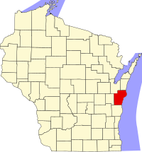
 郡のウィスコンシン州内の位置
| |
 州のアメリカ合衆国内の位置
| |
| 設立 | 1836年 |
| 郡庁所在地 | マニトワック |
| 最大の都市 | マニトワック |
| 面積 - 総面積 - 陸 - 水 |
3,869 km2 (1,494 mi2) 1,532 km2 (592 mi2) 2,337 km2 (902 mi2), 60.40% |
| 人口 - (2010年) - 密度 |
81,442人 54人/km2 (140人/mi2) |
| 標準時 | 中部: UTC-6/-5 |
| ウェブサイト | www |
郡政府
編集郡執行役(郡長)はボブ・ジーゲルバウアであり、2006年4月に選出されてから現職にある。郡政委員会は25人の委員で構成されている。
地理
編集アメリカ合衆国国勢調査局に拠れば、郡域全面積は1,494平方マイル (3,870 km2)であり、このうち陸地592平方マイル (1,530 km2)、水域は902平方マイル (2,340 km2)で水域率は60.40%である[3]。
主要高規格道路
編集- 州間高速道路43号線
- アメリカ国道10号線
- アメリカ国道151号線
- ウィスコンシン州道32号線
- ウィスコンシン州道42号線
- ウィスコンシン州道57号線
- ウィスコンシン州道67号線
- ウィスコンシン州道147号線
- ウィスコンシン州道310号線
隣接する郡
編集-
マニトワック郡催事広場
-
キール市の郡入り口標識
-
マニトワック郡監獄
人口動態
編集| 人口推移 | |||
|---|---|---|---|
| 年 | 人口 | %± | |
| 1900 | 42,261 | — | |
| 1910 | 44,978 | 6.4% | |
| 1920 | 51,644 | 14.8% | |
| 1930 | 58,674 | 13.6% | |
| 1940 | 61,617 | 5.0% | |
| 1950 | 67,159 | 9.0% | |
| 1960 | 75,215 | 12.0% | |
| 1970 | 82,294 | 9.4% | |
| 1980 | 82,918 | 0.8% | |
| 1990 | 80,421 | −3.0% | |
| 2000 | 82,887 | 3.1% | |
| 2010 | 81,442 | −1.7% | |
| WI Counties 1900-1990 | |||
|
基礎データ
人種別人口構成
先祖による構成
言語による構成 |
年齢別人口構成
世帯と家族(対世帯数)
|
都市と町
編集| 都市 | 村 | 町 | 未編入の町 | |
|---|---|---|---|---|
|
|
|
| |
脚注
編集- ^ Quickfacts.census.gov - Manitowoc County Archived 2011年7月14日, at WebCite - accessed 2011-12-06.
- ^ Quickfacts.census.gov - Manitowoc, Wisconsin - accessed 2011-12-06.
- ^ “Census 2000 U.S. Gazetteer Files: Counties”. United States Census. 2011年2月13日閲覧。
- ^ Based on 2000 United States Census data
外部リンク
編集- Manitowoc County Official Website - 公式サイト
- The Home Front: Manitowoc County in World War II : The Home Front: Manitowoc County in WWII presents photographic images, oral histories, published sources, artifacts, and other resources which document the county’s home front and wartime experiences from 1939 to 1947.
- Manitowoc Local History Collection : Explore the history of Manitowoc and surrounding communities through more than 1,400 searchable images dating from the late 19th century through 1995. Most of the images were taken between 1890 and 1930. Peruse these images when you are doing historical or genealogical research, school assignments, business or civic presentations, or just for the fun of it! Electronic texts in this collection include: